Why Say No?
All the Independent Consultants commissioned by the Department of Planning have confirmed this is a flawed plan. Option 1 will have a negative impact on heritage, business and visual amenity. It will not meet the Hawkesbury's long term traffic demands, resulting in traffic congestion and queuing. It is a cheap, compromised and short-term band-aid. The Project will also result in the demolition of the historic Windsor Bridge. Our community deserves better.

Traffic
From early document released by the RMS it was clear that Option 1 was not going to serve the ever increasing needs of road users. In a Questions and Answers document from June 2012, the RMS wrote
"Q: Why select a preferred option that provides very little traffic improvement?
A: The traffic performance of the preferred option is largely related to the Macquarie Street / Bridge Street and the Windsor Road / Hawkesbury Valley Way intersections... Modelling shows that these key intersections could not accommodate the predicted future traffic volumes and the models indicated traffic congestion." In short, the issue of traffic flow relates to the intersections rather than the bridge itself.
The independent traffic report from Cambray Consulting, who were commissioned by the Department of Planning and Infrastructure, is particularly damning in their report on the Bridge St intersections. When looking at the traffic modelling for the Bridge St/George St intersection, they found the "...intersection is expected to be operating very close to acceptable limits of operation at the assumed year of opening of the project (2016)" (pg 24). Similarly on page 25, it states “The Bridge Street / Macquarie Street intersection is expected to be operating outside of acceptable limits of operation at the assumed year of opening of the project (2016).” There are no plans to address the issues of the Macquarie St intersection as it is outside the scope of the project.
In Stage 2 of the project, the bridge lanes will be remarked to allow two southbound lanes, but only one northbound lane. These will not be contraflow. Cambray responds to this on page 11: “And whilst the proposed ultimate configuration of the bridge is one northbound lane and two southbound lanes, the highest volume forecast by RMS is in fact the northbound volume during the PM peak. This implies to us that the additional southbound capacity may be intended to accommodate the southbound queue back from the George Street intersection, rather than purely to provide additional capacity over the bridge itself...”.
Added to this is a finding from Cambray that the traffic count for the Freemans Reach/Wilberforce Rd intersection and the George St / Bridge St intersection was carried out during the school holidays. “We note that these counts were undertaken on 12 July 2011, which we understand was during the NSW school holidays. Generally school holiday periods should be avoided when doing traffic counts, as the traffic conditions are generally not representative of ‘typical’ conditions." (pg.30). Concerns were also noted in regard to the method of collection of traffic data for the Macquarie St intersection; "...loop detectors which collect SCATS data (which we understand was used for modelling of the Bridge Street / Macquarie Street intersection) typically undercount in congested conditions. It also appears that there is no SCATS data for the northbound left turn movement at this intersection (one of the heaviest movements), due to the lack of a loop detector in this lane.”
So what do Cambray make of project planning? "In summary, based upon the information provided to us, it appears that the scope throughout much of the duration of the project has focussed on justifying the preferred option, as opposed to undertaking a thorough investigation into alternative options.” (pg. 70)
In their concluding statements on page 70, Cambray states “We suggest that it may be prudent to ‘step back’ and undertake a broader study to investigate long term solutions, and once a preferred long term solution is identified, consider a staged approach or interim treatments to progressively deliver that long term solution. This would avoid investing substantial funds into a traffic route which will have a limited ‘life’ due to constrained intersection capacity on the roads feeding the bridge." This supports CAWB's position of retaining the existing bridge for light and local traffic, and the planning for a bypass that will provide a long term solution to traffic.
Download CAWB's Traffic Report in response to the EIS.
| traffic.pages | |
| File Size: | 1466 kb |
| File Type: | pages |
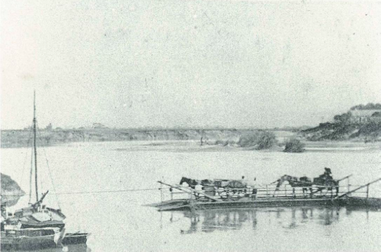
 Ferry at Windsor
c.1860-70 Image: Hawkesbury City Council Library and RMS
Heritage
Every heritage advocacy group, including the independent consultants hired by the government, has denounced this project due to the significant impact on heritage. The Heritage Council of NSW has repeatedly condemned the Option 1, stating in a letter to the RTA dated 9 September 2011, that the Project is “likely to have a long term irrevocable and negative impact on Windsor as a whole and Thompson Square in particular.” The Heritage Council considered that "...the exclusion of through traffic from Thompson square would contribute significantly to re-establishing its heritage significance as one of the last remaining Georgian spaces in Australia.".RTA. (2011) Windsor Bridge Over Hawkesbury River:Options Report, August 2011, p 53.
The Statement of Heritage Impact in the EIS states that "From a heritage perspective the most appropriate mitigation measures for Thompson Square and Windsor Bridge are to select an alternative river crossing location that avoids impacts on Thompson Square and to refurbish and retain the existing Windsor Bridge for light vehicles or pedestrians."(pg. 344). This sentiment is echoed in the Casey and Lowe report. One of the recommendations states " Given that the bridge is considered an item of state significance within the EIS, give further consideration to options for the proposed route that retain the bridge to provide either a primary or secondary use."
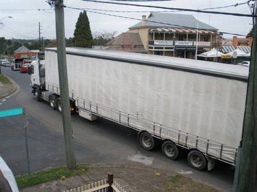
Unfortunately,Thompson Square has been impacted by previous unsympathetic, piecemeal road 'improvements' to the bridge and approach roads. The Bridge Street approach road (cut into Thompson Square in the 1930s for modern traffic demands) dissects the central grassy park reserve into two irregular 'wedges'. Nevertheless Thompson Square still retains the village square character originally intended by Macquarie. Option 1 will place approach roads through Thompson Square and funnel through traffic (including trucks) into this important civic space, and will forever remove the potential of fully restoring Thompson Square. It will remain a permanently compromised space under the Option1.
It is worth noting that Mr Ray Williams, member for the Hawkesbury, is on the record as saying that he believes the heritage issues relating to Thompson Square are a "red herring". Mr Kevin Conolly, member for Riverstone, has on a number of occassions been quoted as saying Option 1 will enhance the heritage values of the Square.
Whilst one of the project objectives has been to reduce the impact on heritage, Casey and Lowe have found "The proposed mitigation measures do not avoid impacts on heritage significance.".
Read more about the symbolism and history of Thompson Square here.
Read more about potential impacts of Option 1 here.

Business Impact
CAWB questions unsupported statements that the Project will improve and revitalize the struggling Windsor Town Centre when, after completing numerous studies, the RMS itself concluded that, “the location of the replacement bridge would have minimal impact on the number of patrons visiting the Windsor town centre. A location in the same place or further upstream or downstream would have minimal impact on the current economic viability of the town centre and/shopping precinct.” RTA. (2011) Windsor Bridge Over Hawkesbury River:Options Report, August 2011, p31. In other words, their studies have shown that a bypass would not negatively impact commerce and local business. Consider too, that this scenario is without the retention of the existing bridge.
CAWB asserts that local businesses cannot expect that the Project will increase business turnover. Rather, local businesses may have cause for concern as the RMS has suggested that when it restructures the intersection at Bridge and George Street it will remove existing right hand turns. It has stated that, "Vehicles would not be permitted to turn right into George Street east (from Bridge St south) as this would result in unacceptable Level of Service for the intersection as a whole." Most concerning is the plan at Stage Two of the project, where traffic will be restricted from turning into the town in peak hour times. This will restrict vehicle access to the businesses in the Thompson Square precinct. "To reduce queue lengths to acceptable levels, the right hand turn from Bridge Street north into George Street west may have to be banned in the PM peak period. This would... reduce queue length to acceptable levels." RMS, EIS, 2012 Chapter 7.3, pgs 236 - 239
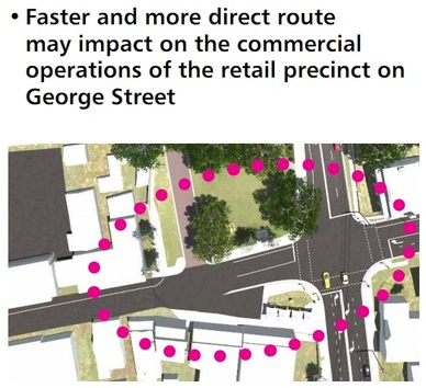
It is worth considering that saturating an area with traffic does not guarantee the commercial viability of businesses. This can be seen on roads with high traffic volumes such as Parramatta Road in Sydney. This issue was also raised by the RMS in 2011 when they stated "Faster and more direct route may impact on the commercial operations of the retail precinct of George St". RMS, Preliminary Urban Design and Heritage Review of Option 1, 2011, p 28
Further, during the construction period (estimated to be at least 12 months) local businesses will experience significant disruption (especially those businesses located near Thompson Square and which rely upon its amenity). The RMS has stated that , "There is potential that the park at Thompson Square would be unusable or unattractive to visitors throughout the 12 month construction period."
In addition, "construction workers are likely to require parking on or near the construction site which would reduce the availability of parking for existing centre patrons." Also, " there are likely to be delays in accessing the town centre due to detours required to enable construction work along the approach to the existing bridge." RTA. (2011). Windsor Bridge Over Hawkesbury River:Socio-Economic Investigations, August 2011,p23.

